
Use OpenStreetMap (OSM) as source data, not as a ready-made game level. A dependable workflow is to define the gameplay meaning of OSM tags, acquire a versioned extract, convert latitude/longitude and tags into your own intermediate schema, generate meshes, collision and navigation assets, and then package or stream those assets. For small areas, query Overpass; for large or repeatable builds, use a regional or planet .osm.pbf extract. Keep attribution and Open Database License (ODbL) decisions in the pipeline from the first import.
What OpenStreetMap gives your game—and what it does not
OSM is a community-maintained geographic database. Its nodes, ways and relations describe features with tags such as highway=primary, building=yes, landuse=forest or amenity=school. Those records are useful raw material for a world, but they are not level-design objects. A road way has no guarantee of lane count, width or playable surface; a building may have no height; and two nearby communities may tag the same feature differently.
As an Amazon Associate I earn from qualifying purchases.
Your first job is to define game semantics. Decide which OSM features become drivable splines, pedestrian paths, building footprints, terrain materials, vegetation masks, spawn points or points of interest. Write those rules before importing data so that a changed tag does not silently change gameplay. Preserve each source object’s OSM ID and source version in an intermediate dataset. That provenance lets you explain a generated asset, compare two imports and regenerate the world when the map changes.
Do these 3 things before closing this tab:
1Scan for outdated or missing drivers - takes under a minute2Repair Windows errors before they cause bigger problems3Fix the driver behind crashes, sound loss and screen glitchesChoose an acquisition method at the right scale
The OSM editing API is designed for editing operations, not production read-only downloads. The OSM Developer FAQ and API policy point developers to Overpass for filtered queries and to planet or regional extracts for larger volumes. Selecting the wrong source creates either an unreliable build or an unnecessary data and server burden.
#1 Best Overall

- BLUE LIGHT BLOCKING GLASSES: Our blue light glasses for women boast UV400 protection, blocking harmful blue rays from computer screens. With these bluelight glasses women, you can enjoy gaming, reading, or watching TV with no worries of eye strain.
- EYE RELIEF: Our blue light glasses are engineered to reduce blurry vision or strain caused by prolonged screen time. These womens blue light glasses aid in better sleep by preventing blue light from disrupting your natural sleep cycle, helping you fall asleep faster and enjoy a more restful night's sleep, making them the perfect christmas present.
- COMFORTABLE: Crafted from durable material, our trendy blue light glasses for woman or blue light glasses men ensure long-lasting comfort. The high-transmittance lenses accessories, gamer gifts for men, help keep your eyes relaxed. Perfect stocking stuffers, gifts for gamers men, christmas gifts for men, halloween costumes.
- LIGHTWEIGHT: These clear blue light glasses feature a lightweight frame, meaning they’ll stay comfy for long-term wear. Perfect as blue blockers glasses for women or mens blue light glasses, these non-prescription fake glasses for men can be worn throughout the day. The blue light blocking glasses women feature polycarbonate HD lenses, which are anti-reflective and restore true color.
- WORRY-FREE PURCHASE: If you experience any issues, our support team is ready to assist you quickly. These are the perfect costume glasses for cosplay dressing up.
| Method | Best fit | Strengths | Limitations and operating notes |
|---|---|---|---|
| Overpass query | A bounded city, route corridor or prototype area | Flexible tag and geographic filters; downloads only the features you request | Shared infrastructure, query timeouts and rate limits make it unsuitable for repeated, very large production imports. Save the response and query parameters as a versioned snapshot. |
Regional .osm.pbf extract |
A complete game region or recurring build pipeline | Repeatable, offline-friendly and efficient for bulk processing; you control filtering and conversion | Requires local storage and processing. You must build your own tag selection, validation and update process. |
Planet .osm.pbf |
Worldwide or multi-region processing, or a central data warehouse | One comprehensive source for repeatable imports and cross-region consistency | Large download, storage and processing requirements. Filter early so game tools do not carry irrelevant features. |
| Hosted raster or vector tiles | A visual prototype or a service whose provider explicitly permits your use | Fastest path to displaying a map; no tile-generation pipeline at the start | OSM-operated endpoints are best-effort, have limited capacity and no guaranteed service level. Heavy use can be blocked, and provider policy may restrict caching or redistribution. Production games should self-host or use a permitted third-party service. |
| OSM editing API | Submitting edits back to OSM | Appropriate for editing workflows | Do not use it as your production read-only download source. |
Example: a bounded Overpass export
For a prototype, issue one query for the exact bounding box and tags you need, then archive the returned file. This illustrative Overpass QL query requests roads, buildings and landuse polygons and includes referenced geometry:
[out:json][timeout:60];(way["highway"](S,W,N,E);way["building"](S,W,N,E);way["landuse"](S,W,N,E););out body;>;out skel qt;Replace S,W,N,E with south, west, north and east coordinates. In a build system, record the query text, endpoint, retrieval time and response hash. If the query times out, split the area into smaller boxes or move to a regional extract rather than repeatedly increasing load on a shared service.
When an extract is the better foundation
Use a regional or planet extract when you need deterministic rebuilds, many adjacent tiles, nightly processing or offline development. Keep the original .osm.pbf unchanged as an input artifact and create filtered derivatives for each game subsystem. A fresh extract is not automatically a compatible update: tags, geometries and object relationships can change, so run the same validation and schema-version checks for every import.
Recommended Free Tools
Design an intermediate game data model
Do not send raw OSM tags directly into your engine. Normalize them into a schema that is stable even when mapping conventions evolve. A practical record includes the source object type and ID, source timestamp or extract identifier, geometry, normalized tags, confidence flags and the generated asset IDs that depend on it.
Rank #2

- WINDEX GAMING WIPES: effortlessly clean all your gaming gear and gaming electronics in one easy step with our new Windex Gaming Wipes
- AMMONIA FREE: our ammonia-free formula is safe to use on all of your favorite gaming equipment like consoles, headsets, controllers, screens, keyboards, and more
- PRE-MOISTENED WIPES: each wipe instantly removes dust, dirt, and stubborn smudges and fingerprints leaving a streak-free shine
- ANTI-STATIC: great for cleaning and wiping down your gaming gear and electronics leaving behind no visible residue
- COMPACT RESEALABLE PACKAGE: store your pack of Windex Gaming Wipes anywhere in your home for whenever a quick and easy wipedown is needed
| OSM feature | Typical game representation | Required data and fallbacks |
|---|---|---|
highway ways |
Road centerline, drivable spline, sidewalk or trail graph | Use classification tags for speed and surface where available. If lane count or width is missing, apply a documented class default and mark the result as inferred. |
building polygons |
Footprint, extruded mesh, interior proxy and collision shell | Use height or level tags when present. Otherwise choose a game-specific default by building class and retain a “height inferred” flag. |
landuse, natural and surface tags |
Terrain material, biome mask, vegetation density or traversal cost | Resolve overlapping polygons by an explicit priority order; assign an “unknown” material instead of dropping an area. |
amenity, shop, tourism and similar points |
Points of interest, mission anchors, signs or fast-travel nodes | Keep the source category and a gameplay category separately so designers can retune the mapping without re-downloading OSM. |
| Relations | Multipolygons, route relations, boundaries or grouped features | Resolve members before meshing. Reject incomplete relations with a logged fallback rather than producing malformed polygons. |
Coordinate normalization
OSM coordinates are geographic latitude and longitude. Convert them to a local projected coordinate system before calculating distances, widths or physics. Choose an origin near the playable area, transform to metres, and store the inverse transform for debugging and attribution tools. A local coordinate frame avoids the distortion and floating-point precision problems that appear when an engine uses large global longitude/latitude values directly. Keep the original geographic coordinates alongside the projected geometry so you can inspect a feature in standard OSM tools.
Geometry cleaning and simplification
Validate polygon winding, close rings, remove duplicate vertices and repair self-intersections before triangulation. Split geometries that cross tile boundaries only after maintaining a stable source-object reference. Generate several levels of detail (LOD): retain more vertices near the player and simplify distant roads, coastlines and building footprints. Use the same simplification policy on every build; otherwise small geometric changes will cause noisy asset diffs.
Build the world in repeatable stages
- Define the playable boundary. Draw the actual world, streaming cells and a small surrounding buffer. The buffer prevents visible gaps at the edge of roads, terrain and navigation data. Document whether the boundary follows a rectangle, administrative boundary or custom polygon.
- Declare gameplay semantics. Map tags to road classes, traversable surfaces, building archetypes, water, vegetation and points of interest. Set explicit priorities for overlapping tags and defaults for missing values.
- Acquire and freeze an input snapshot. Download through Overpass for a bounded prototype or store a regional/planet
.osm.pbffor production. Record the source date, query or extract name, checksum and geographic bounds. - Parse and validate. Resolve node, way and relation references; check required tags; report invalid rings, missing members and unexpected object counts. Fail the build on structural errors that would create unsafe navigation or broken meshes, and quarantine recoverable features for fallback processing.
- Project and normalize. Convert coordinates to your local metre-based frame, normalize units and write the intermediate schema. Keep source IDs and tags in a provenance table rather than baking them irreversibly into meshes.
- Generate terrain and thematic masks. Rasterize landuse, natural, surface and water features into material, vegetation and traversal layers. Resolve overlaps deterministically and fill unknown cells with a visible, testable fallback material.
- Generate roads and paths. Convert centerlines into splines or graph edges, create junction connectivity, and derive width, speed and surface properties from available tags. Separate visual shoulders from collision lanes so art changes do not invalidate traffic logic.
- Generate buildings and structures. Triangulate footprints, extrude by measured or inferred height, create simplified collision and assign archetypes. Keep interiors optional; OSM rarely provides the room-level detail needed for a complete interior.
- Build simulation assets. Produce collision meshes, navigation graphs or navmeshes, traffic lanes, cover markers and points-of-interest indexes. Run reachability tests so a geometry repair does not leave isolated regions.
- Tile and package. Split render, collision and navigation data using the same world grid, write a manifest with asset versions and dependencies, and package bounded worlds locally or expose tiles through a cache-aware backend.
- Test regeneration. Re-run the complete pipeline from the frozen input on a clean machine or build worker. Compare manifests, inspect changed source IDs and perform a playable smoke test before publishing an update.
Turning common OSM features into playable systems
Roads, traffic and navigation
OSM road ways are centerline geometry, not lane meshes. Build a graph first: split at intersections, preserve one-way direction, and carry bridge, tunnel and layer information where present. Then generate visual pavement and collision from the graph. If lane information is absent, use a documented road-class rule and expose the inferred value to designers. Do not assume every connected line is drivable; footways, service roads and construction features need separate traversal policies.
Free tools Windows power users keep installed
One-click scans. No signup required.
Buildings
Footprints are often the most reliable building signal. Extrusion height may come from a height or level tag, but many footprints lack either. Use a conservative archetype fallback, mark it as inferred and avoid presenting the result as a measured real-world height. For performance, generate a detailed near-player mesh and a simplified distant shell, while keeping collision simpler than the render mesh.
Rank #3

- Ergonomic & Adjustable Design: Fight "text neck" and improve your posture. Designed for comfort, it offers an adjustable height (7.1in-8.5in) (1.4in adjustable range) and angle (5°-85°) Please note: cell phone stand is only 9 inches tall—the length of a standard pencil
- Without blocking subtitles Perfect for office desk Tiktok Face Time Zoom video—this is the ultimate kitchen desk essential for phones! Perfect viewing experience while reducing neck back strain, A must-have for gamers streamers desk, and anyone who values both style and support!
- Sleek & Stable Design fits Otterbox Case: Say goodbye to bent cables, tangles, and tip-overs! LISEN’s stylish adjustable desk phone holder features a built-in charging hole and smart cable management, keeping your phone secure and your workspace clutter-free cool gadgets for men
- ANTI-SLIP DESIGN free hands: The under 10.00 items easy gadgets back and the bottom of this kitchen essentials for women are fully covered by anti-skid silicone, which LISEN stand up desk decor can provide maximum protection device from any scratches and slides
- Your Perfect Viewing Companion:If your product arrives damaged or breaks within 365 days, reach out to LISEN for a quick and hassle-free solution. Struggling with assembly, like tightening the screw? We’ve got your back! Your experience matters to us. (Product including: phone Holder stand*1, screw*1, hexagon screwdriver*1, specification*1)
Terrain, water and vegetation
Landuse and natural polygons are useful classification masks, not complete terrain elevation. Combine them with your own elevation source if the game needs hills, cliffs or floodable volumes; OSM alone does not guarantee a height field. Clip water and land polygons consistently at tile edges and preserve a no-data class so missing coverage is visible during QA.
Points of interest
Amenity, shop and tourism tags can seed missions, signs or discovery systems. Treat them as candidate locations: verify that the feature is inside the playable boundary, de-duplicate nearby points and allow designers to disable sensitive or unsuitable categories. Keep the original category in metadata for attribution and future remapping.
Using OpenMapTiles for a self-hosted tile pipeline
OpenMapTiles documents a workflow for importing an .osm.pbf file into PostgreSQL, running mapping SQL, calculating a bounding box and generating vector tiles or an .mbtiles file. That workflow is useful when your game needs a controlled tile database rather than direct calls to a public tile server.
Quick wins for a faster PC:
Repair Windows errors before they cause bigger problemsFix Now →Scan for outdated or missing drivers - takes under a minuteDriver Scan →Clear out junk files and repair common Windows errorsFree Scan →- Load the selected regional or planet-derived
.osm.pbfinto PostgreSQL using the documented OpenMapTiles import process. - Run the mapping SQL that converts OSM objects into the tile layers your client needs. Remove layers that have no gameplay or UI purpose to reduce storage and transfer.
- Calculate and verify the bounding box. Check that it covers the playable area plus the streaming buffer and does not accidentally include an entire continent.
- Generate vector tiles or an
.mbtilesarchive. Validate representative tiles at every zoom or detail level before conversion to your engine’s runtime format. - Serve the resulting files from infrastructure you control, or package them with a bounded game. Keep the input extract, SQL version and generated archive linked in the build manifest.
Vector tiles are still cartographic data. You normally need a second conversion stage for collision, navigation and high-detail meshes; do not mistake a display tile archive for a complete playable world.
Rank #4

- Easy Installation: Our gaming lights have been designed to enhance your entertainment experience. Simply position the led light bar next to your TV or game console to create a game room environment with ease. They come with USB power and a 60 inch cord for direct mounting and mobility
- Audio Syncing & Extensive Mode: The built-in high-sensitivity music sensor allows you to sync the TV led lights to your favorite music. Lights react and move to the beat of music, film and game audio, creating an incredible immersive sound and light experience – and all without the need for an additional hub. You can choose from 64+ patterns, including strobe, illusion, jump, energy, gradient, running, chasing, fluttering mode etc. Each mode can be applied to different scenes
- 64+ Chasing IC+RGB & W Effect: The independent control design of IC+RGB and white all-in-one multifunctional rgbw led bar lights monitor backlight allows you to easily switch the led lights for desk between IC+RGB and white to enjoy a variety of lighting effects, you can choose white lighting mode with high brightness for better illumination when working, etc. Choose IC+RGB lighting mode when you need to create an entertaining atmosphere for the light show, 16 million colours of Color changing rgb light bar let you dance to the beat and create a dynamic party atmosphere
- Dynamic and Dimmable Lights: 1%-full brightness free brightness adjustment gives you the flexibility to adjust dimmable led light bar for room decorations or a variety of occasions
- USB Powered: USB light bars for room can be powered by powernank, usb charger, TV, Monitor, laptop PC mainframe, making behind TV led lighting bar easy to install in any location.TV led lights are powered by the TV usb interface / PC mainframe, can be turned on/off synchronously with TV / PC
Package locally or stream through your own service
Bounded, offline worlds
For a fixed map, ship compressed render tiles, mesh bundles, collision and navigation chunks with a manifest. Include only the detail levels the game needs, keep source IDs in a separate metadata file, and verify package checksums at install time. This approach avoids runtime dependence on an external tile endpoint and makes offline play predictable.
Large or changing worlds
For a large world, stream chunks through a cache-aware service. Use immutable versioned paths for released data, cache popular cells, and keep render, collision and navigation versions compatible. A manifest should tell the client which chunk versions belong together; otherwise an update can combine a new road mesh with an old navigation graph.
OSM’s own raster and vector tile servers are intended for reasonable use, not as an unlimited commercial game backend. Their policies describe best-effort capacity and the possibility of blocking heavy use. Self-host generated tiles or select a provider whose terms explicitly permit your traffic, caching and redistribution.
ODbL licensing and commercial release decisions
OSM data is licensed under the Open Database License (ODbL). The OSM Foundation’s computer-game guidance treats selective import and rearrangement of OSM records as a derivative database. A public game pipeline that extracts, filters or rearranges OSM data can therefore create obligations even when the player mainly sees rendered graphics.
Best Value
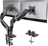
- Compatible with Wide Screens - To ensure compatibility with the dual monitor mount, your each monitor must meet three conditions at the same time: First, computer screens size range: 13 to 32 inches. Second, screen weight range: 4.4 to 19.8 lbs. Third, the back of the monitor screen must have VESA mounting holes with a pitch of 75x75mm or 100x100mm.
- Regarding the compatibility with desks - Your desk must meet three conditions at the same time: First, desk material: Only wooden desks are recommended, plastic or glass desks cannot be used. Second, desk thickness range: 0.59" - 3.54". Third, the bottom of the desk should not have any cross beams or panels, as this will interfere with installation. We recommend carefully checking that your desk and monitors meets all above conditions before purchasing.
- Dual C-Clamp Hold - Worried your dual monitors might wobble or slip? Our upgraded base uses a larger platform plus a dual C-clamp structure to lock the dual monitor arm firmly to your desk. Each arm safely keeps your screens steady while you type, click and game—no shaking, no sliding, just a clean and secure setup you can trust every day. It also provides Grommet Mounting installation choice, both options ensure stable and secure fixation for your 0.59" - 3.54" desk.
- Full-Motion Adjustment For Comfortable View - Pull the screen closer when you’re deep in a spreadsheet, push it back to watch videos, or rotate to portrait for coding — moving everything smoothly with just one hand. The monitor stand offers +85°/-50° tilt, ±90° swivel and 360° rotation. Raise your monitor up to 15.75″ to support a healthy sitting posture. Whether you’re working from home, gaming through the night, or switching between video calls and documents, getting the screens to your natural line of sight helps relieve neck, shoulder and back strain so you can stay focused longer with less fatigue.
- Keep Your Desk Organized: By lifting both screens off the desktop, this dual monitor stand opens up valuable space for your keyboard, notebook, docking station or a simple, clutter-free work area. Built-in cable management guides wires along the arms, keeping cords out of sight and out of the way. Enjoy a tidy, modern workstation that looks as good as it feels to use.
The practical distinction is between the database and a produced work. A rendered scene, video or other output may be a produced work, while an embedded or distributed collection of OSM-derived records remains database material. The Foundation’s licence FAQ states that if you distribute OSM data onward to third parties, it must be under the ODbL. It also explains that recipients of a produced work can request the OSM data and derivative database used with it. The exact boundary depends on how your game stores and exposes data, so obtain legal advice for your architecture and recheck the current ODbL guidance before launch.
Build compliance into the pipeline
- Record which OSM snapshot, extract or query contributed to every released asset set.
- Keep the original data and any derivative database needed to satisfy an applicable redistribution offer, rather than deleting them after meshing.
- Document your filtering, transformation and mapping SQL so you can provide the corresponding data and describe what changed.
- Decide whether your client, patcher, server API or mod tools distribute OSM-derived database content; treat each delivery path separately.
- Have counsel review whether your generated assets are a produced work, a derivative database, or both under your implementation.
Make attribution visible in the game
Display a clear notice such as “© OpenStreetMap contributors” or “Map data from OpenStreetMap.” Put it where players can read it: the map screen, a persistent map overlay, a credits panel and, when appropriate, a loading or pause screen. Include a link to the current OpenStreetMap copyright page in credits or the map UI when your platform supports links. Do not hide attribution behind an obscure toggle, place it off-screen or show it only in a developer build. If your game has multiple map modes or downloadable regions, ensure the notice remains available in each relevant mode.
Updates, diffs and missing coverage
OSM changes continuously and coverage varies by location. Version every import with the extract date, source identifier, checksum, schema version and generator version. Keep a table linking source IDs to generated asset IDs so an update can rebuild only affected tiles while still allowing a clean full regeneration.
What’s actually slowing this PC down?
Pick the symptom - the matching free tool is one click away.
When a new extract arrives, compare object additions, deletions, tag changes and geometry changes. Re-run validation, regenerate dependent collision and navigation, and inspect a sample of changed cells in-game. Deleted roads must disappear from traffic and navigation graphs; changed building footprints must invalidate their old collision; and a moved point of interest must not leave a duplicate at its former position.
Design for missing data rather than treating it as exceptional. Use fallback geometry for a building with no height, an “unknown” material for an unclassified polygon and a generic traversable rule for a path with incomplete tags. Log each fallback with its source ID and expose counts in build reports so a region with sparse mapping does not quietly ship with broken gameplay.
Troubleshooting common failures
| Symptom | Likely cause | Recovery |
|---|---|---|
| Overpass request times out | Area or tag set is too broad, or shared service is busy | Split the bounding box, narrow the filters, cache successful responses, or switch to a regional extract for production. |
| Buildings or roads have holes | Unresolved relation members, invalid rings or tile clipping performed too early | Validate and repair geometry before clipping; log incomplete relations and apply a visible fallback. |
| Roads drift or widths look wrong | Latitude/longitude used as engine metres, or inferred dimensions are undocumented | Project to a local metre-based frame and store whether each width or height was measured or inferred. |
| Navigation does not match the rendered world | Collision/nav data generated from a different asset version | Use a shared manifest and rebuild all dependent chunks when source geometry changes. |
| Tile endpoint blocks requests | Reliance on a best-effort public server or excessive client traffic | Stop direct production traffic, self-host generated tiles or use a provider with explicit permission and capacity terms. |
| Legal review finds missing attribution or data offer | Compliance added after asset generation | Trace assets through the provenance table, preserve the source and derivative database, add visible attribution and obtain licence advice before release. |
A practical decision checklist
- Prototype in one district: use an archived Overpass query, a local projection and a small generated asset set.
- Ship one city or region: use a regional
.osm.pbf, self-host generated tiles, and keep a reproducible import and update job. - Support many regions: standardize the intermediate schema, process regional extracts in isolated jobs and publish immutable versioned manifests.
- Need a map display but not world geometry: consider vector tiles, while still checking provider policy, attribution and caching terms.
- Need a fully offline commercial game: package generated assets and the compliance materials required by your ODbL analysis instead of depending on runtime public endpoints.
The durable architecture is the same in every case: acquire an appropriate snapshot, preserve provenance, transform OSM into explicit game semantics, generate all runtime assets from one versioned build, and make licensing and attribution visible to players. That turns a community map into a maintainable game-world supply chain rather than a fragile one-off import.
Quick Recap
Product prices and availability are accurate as of the date/time indicated and are subject to change. Any price and availability information displayed on Amazon at the time of purchase will apply.
The Tool Desk
Outbyte Driver Updater FREEFix the driver behind crashes, sound loss and screen glitchesFind Drivers →Outbyte PC Repair FREEClear out junk files and repair common Windows errorsFree Scan →
